

Oft recommended, but I knew little about it (other than it was a rather large canyon), so I was looking forward to finding out what the fuss was about.
Even though the sun was shining, it was bitterly cold due to the strong wind that was constantly blowing. Getting out of bed and getting out of the car long enough to make breakfast was a challenge today. Starting to wonder how we’re going to cope in Tasmania… At least we’re nice and warm in bed at night.

 There were a few walking options, but we went for the walk around the rim of the canyon. The walk started with a climb straight to the top, so we weren’t cold for very long! It wasn’t difficult, but sucking in all that cold air reminded me of the pain I’d feel in my throat/lungs when climbing to the summit in Niseko. But, even from here the view was spectacular. Though, not knowing what was ahead, I didn’t see what the fuss was about. The walk was only 7km, but with all the stopping to take photos, and just to take it all in, it took us the best part of four-hours.


 The walk moved away from the edge of the cliff slightly, and we were now surrounded by rocky, beehive-shaped rocks. Not something that is easy to see in photos (as it’s all the one colour). Again, geology nerds would be in heaven.
 The trees (which believe it or not still showed signs of life) were probably the most twisted and tortured looking trees I’ve yet seen. They were bent and twisted, and almost appearing like they had been melted.

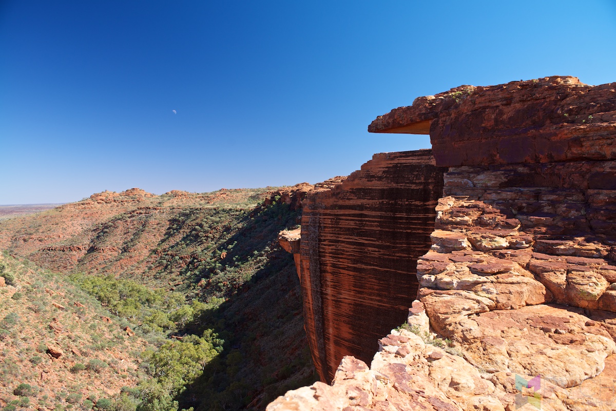


 The next lookout, after all the beehive domes, showed what the canyon was all about. The other side of the canyon looked like it had been cut with a hot knife, and the side that we were on was full of undercut cliffs with over-hanging ledges that made me feel incredibly uncomfortable just looking at them. I had no idea what was underneath me when I was standing on the edge of the cliffs. Also, it was the first time I’d noticed something so dangerous here in Australia that wasn’t protected by fences to stop you falling to your death. Good to see them putting the responsibility of your life into your own hands (fences are ugly).


 I can’t really describe it, other than it was very large, very red and very impressive – I’ll let the pictures do the talking. Kata Tjuta it ain’t, but it’s certainly something that you’d make a (potentially large) detour to visit. I recommend it.

 We considered spending the night in the day-time use only picnic area at the base of the canyon, but it was only 1:30, so we kept going towards the West MacDonnell Ranges. There is a unsealed loop road that saves us driving back to Stuart Highway, for the price of $5.50. First 80km-or-so was great, comfortably cruising at 80kph, but I think I got a little cocky talking about how great this road was, and that’s when the corrugations started. 40km of unpredictable road – some smooth, some sandy, some with giant corrugations. Still, better than driving all the way back to the Stuart Highway, and it made me thankful to have a 4WD.
 Passed Gosse Bluff turnoff, and not knowing what it was (and with the sun fast approaching the horizon) I didn’t bother to investigate. A little further on (and where we considered spending the night, except it was far too windy) we got a proper view of it (and read the information board). It’s another meteor crater, but you can (maybe) see from the photo just how large it is. I thought it was just a small mountain range…
 Also, these random melons that grow like weeds on the side of the road. I collected one of each, and will cut them open and give them a try tomorrow…
48日目 6月30日(日) キングスキャニオン!!
今日は、ウルルーから150kmほどのこの辺りのもう一つの見所、キングスキャニオンにご対面の日です。
朝は、風も強くかなり冷え込んでいました。 でも今の所羽毛布団と、フリースのブランケットで眠りにつくときは、ちょっと暑いと感じる位なので、夜の防寒対策は、ばっちり☆
にしても朝ご飯の支度をするなり外で行動を開始するには、寒いので先にデリちゃんで、車泊したレストエリアから日の出前に出発!
キングスキャニオンは、こないだ見た映画、プリシラでも出てくる場所でいつか行ってみたかったのでワクワク!
ピクニックエリアで朝食をすませ、いざ6kmのキングスキャニオン散策に出発!
風がかなり強いので、ウィンドブレーカー上下でちょっとかっこ悪いけど、寒さ対策。(子供達は元気に半そで、短パンだったけど笑)
しょっぱなは、急な石の階段を30、40分ほどひたすら登り。すると頂上で素晴しい景色が待っていました!
赤い岩の崖が、360°視界に広がっていました。 キングスキャニオンのベースの岩肌は、エアーズロックのなめらかな岩肌とも、カタジュタのごろごろした岩肌とも違い 、ミルフィーユケーキの様な薄い層状の岩が何層にも重なっていますが、キングスキャニオンの渓谷部分は、キレイで滑らかで、ナイフで切った様になっています。
渓谷の下には、崖が少しずつ崩落した際の大きな岩の塊がゴロゴロところがっていて、岩の頂上に降った雨が岩から染み出ることでできた川と池が広がり、その周りだけ突然緑が広がりオアシスの様になっています。
キングスキャニオンの頂上は、ドーム状の岩山がポコポコと視界のどこまでも広がっています。
これは、昔、テーブル状だった頂上の岩肌の間に雨などでマス目状に亀裂が入り、そのマス目一つ一つの四方 の溝がさらに浸食されて、それぞれのドームを作り出したそうです。 ドーム状の岩もミルフィーユ状の岩の層でできているので、天然の階段のように登る事ができます。
キングスキャニオン、期待を裏切らない素晴しい絶景をみることができました。
キングスキャニオン散策を終えたのが、2時過ぎ。じっくり、景色を楽しみ、ロスくんは160枚以上の写真をとり、かなりゆっくりペースでだいたい4時間ほどかかりました。
今晩は、この辺りでキャンプをする予定でしたが、ちょっとまだ早いので、マクドナルド山脈国立公園方面へ移動することに。
ここへの道路は有料なので、($5.50)でチケットを買っていざ出発。
無舗装の道路ですが、最初の100kmほどは、コンディションはばっちりでしたが、最後の50kmは、こないだのチェンバーズピラーのガタボコ道路よりひどかった!! あまりの振動で頭痛がしました。
なんとか今晩は、国立公園内のRed bank渓谷キャンプ場($5)に到着できました。
夕食はロスくん大好物、久々のバンガーズ&マッシュ(ソーセージとマッシュポテト) です! おいしかったよ、ありがとー♥


-

- This is the hand basin…


Leave a Reply